1984 Map of Tappahannock
USGS Topo · Published 1990About this map
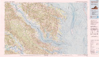
The Rappahannock River and Potomac River dominate this coastal landscape, defining the jagged peninsulas of Virginia’s Northern Neck and Middle Peninsula in the mid-1980s. Key regional hubs like Tappahannock and Warsaw anchor the inland crossings, while the eastern fringes transition into the aqueous environment of the Chesapeake Bay. This maritime character is punctuated by isolated landforms such as Smith Island and Tangier Island, and protected coastal habitats including the Martin National Wildlife Refuge.
Find a feature on this map
174 named features on this map. Tap any name to fly to it.
Don’t see what you’re looking for? This feature index may not catch every label — zoom into the map to look around manually.
Map Details
Editions of this 1984 Tappahannock Map
3 editions found


Other maps of this area

1889 · Fredericksburg
USGS Topo · 1:125,000

1892 · Fredericksburg
USGS Topo · 1:125,000

1892 · Piney Point
USGS Topo · 1:62,500

1892 · Montross
USGS Topo · 1:62,500

1894 · Fredericksburg
USGS Topo · 1:125,000

1894 · Piney Point
USGS Topo · 1:62,500

1894 · Point Lookout
USGS Topo · 1:62,500

1895 · Nomini
USGS Topo · 1:125,000

1895 · Piney Point
USGS Topo · 1:62,500

1895 · Montross
USGS Topo · 1:62,500