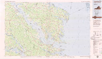
1984 Map of Tappahannock
USGS Topo · Published 1985About this map
Tappahannock and the surrounding Northern Neck and Middle Peninsula landscapes are defined by the convergence of several major tidal rivers into the Chesapeake Bay in this 1984 survey. The map details a complex coastal geography where the Rappahannock River and Potomac River separate distinct rural counties, connected by arterial routes like US Highway 360 and State Route 3. The land use of the mid-1980s is characterized by small agricultural settlements and maritime centers such as Urbanna and Kilmarnock, while the Mattaponi Indian Reservation and Pamunkey Indian Reservation mark significant cultural landscapes along the western rivers. Historical continuity is visible in landmarks such as Christ Church and Rehoboth Church, and the terminus of the Southern Railway at West Point illustrates the era's transport network transitioning toward the bay.
Find a feature on this map
166 named features on this map. Tap any name to fly to it.
Don’t see what you’re looking for? This feature index may not catch every label — zoom into the map to look around manually.
Map Details
Editions of this 1984 Tappahannock Map
3 editions found
Other maps of this area

1889 · Fredericksburg
USGS Topo · 1:125,000

1892 · Fredericksburg
USGS Topo · 1:125,000

1892 · Piney Point
USGS Topo · 1:62,500

1892 · Montross
USGS Topo · 1:62,500

1894 · Fredericksburg
USGS Topo · 1:125,000

1894 · Piney Point
USGS Topo · 1:62,500

1894 · Point Lookout
USGS Topo · 1:62,500

1895 · Nomini
USGS Topo · 1:125,000

1895 · Piney Point
USGS Topo · 1:62,500

1895 · Montross
USGS Topo · 1:62,500