
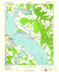
1944 Map of Tappahannock
USGS Topo · Published 1944About this map
The Rappahannock River serves as the central artery for this mid-century portrait of coastal Virginia, dividing the riverfront community of Tappahannock from the rural reaches of Richmond Co. The landscape is defined by historic estates and landings, such as Sabine Hall and Mt Airy, which point to the long-standing plantation and maritime economy of the Northern Neck. Navigation remains vital to the area's identity, evidenced by Hoskins Creek Range Front LT 3 and the prominent Downing Bridge crossing. While Tappahannock shows development near St Margarets School, the surrounding countryside remains dotted with local landmarks like St Johns Ch and Turners School. Numerous water access points including Wares Wharf and Strangeway Landing underscore the reliance on the tidal inlets of Cat Point Creek and Piscataway Creek for local transport and commerce.
Find a feature on this map
43 named features on this map. Tap any name to fly to it.
Don’t see what you’re looking for? This feature index may not catch every label — zoom into the map to look around manually.
Map Details
Editions of this 1944 Tappahannock Map
2 editions found
Other maps of this area

1892 · Piney Point
USGS Topo · 1:62,500

1892 · Montross
USGS Topo · 1:62,500

1894 · Piney Point
USGS Topo · 1:62,500

1895 · Nomini
USGS Topo · 1:125,000

1895 · Piney Point
USGS Topo · 1:62,500

1895 · Montross
USGS Topo · 1:62,500

1898 · Nomini
USGS Topo · 1:125,000

1901 · Piney Point
USGS Topo · 1:62,500

1917 · Morattico
USGS Topo · 1:62,500

1918 · Tappahannock
USGS Topo · 1:62,500