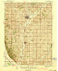
1941 Map of Tarkio
USGS Topo · Published 1941About this map
The Tarkio College campus and the adjacent Tarkio Airport anchor the local landscape in this rural northwest Missouri region. Surveyed just before the decade began, the area is defined by a dense network of one-room schoolhouses and country churches that served an intensive agricultural community. Many of these, such as National Sch, Evening Star Sch, and English Grove Ch, represent the civic heart of now-quiet townships like Polk and Colfax.
Find a feature on this map
61 named features on this map. Tap any name to fly to it.
Don’t see what you’re looking for? This feature index may not catch every label — zoom into the map to look around manually.
Map Details
Editions of this 1941 Tarkio Map
2 editions found

Other maps of this area

1915 · Falls City
USGS Topo · 1:62,500

1915 · Nemaha
USGS Topo · 1:62,500

1920 · Craig
USGS Topo · 1:62,500

1926 · Maitland
USGS Topo · 1:62,500

1936 · Fairfax
USGS Topo · 1:24,000

1939 · Tarkio
USGS Topo · 1:62,500

1939 · Farragut
USGS Topo · 1:62,500

1939 · Skidmore
USGS Topo · 1:62,500

1939 · Hamburg
USGS Topo · 1:62,500

1939 · Nemaha
USGS Topo · 1:62,500