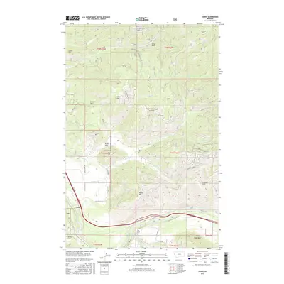
2017 Map of Tarkio
USGS Topo · Published 2017About this map
Tarkio serves as the primary settlement on this landscape, positioned where the valley floor meets the slopes of Lolo National Forest. The geography is defined by the Clark Fork river, which cuts through the southern portion of the quadrangle, drawing several tributaries such as Fish Creek and Nemote Cr from the surrounding highlands. This 2017 survey shows a corridor of human activity concentrated along Old Hwy 10 W and Nemote Creek Rd, reflecting a transportation network that follows the river's path. Local history is anchored at the Tarkio Cem and Fish Creek Cem, while high peaks like Cobden Peak and Ninemile Divide shape the northern horizon. The presence of features like Quartz Pasture and the Longview Ranch Rd suggests a landscape utilized for both forestry and ranching in this portion of Mineral County.
Find a feature on this map
50 named features on this map. Tap any name to fly to it.
Don’t see what you’re looking for? This feature index may not catch every label — zoom into the map to look around manually.
Map Details
Editions of this 2017 Tarkio Map
This is the sole edition of this map. No revisions or reprints were ever made.
Other maps of this area

1911 · Lolo
USGS Topo · 1:250,000

1913 · Lolo
USGS Topo · 1:250,000

1956 · Wallace
USGS Topo · 1:250,000

1956 · Hamilton
USGS Topo · 1:250,000

1959 · Hamilton
USGS Topo · 1:250,000

1959 · Tarkio
USGS Topo · 1:62,500

1960 · Wallace
USGS Topo · 1:250,000

1960 · Hamilton
USGS Topo · 1:250,000

1960 · Superior
USGS Topo · 1:62,500

1960 · Straight Peak
USGS Topo · 1:62,500