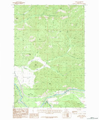
1983 Map of Tarkio
USGS Topo · Published 1984About this map
Clark Fork defines the southern corridor of this landscape, where the river valley provides a narrow path for transport through the steep terrain of the Lolo National Forest. The small settlement of Tarkio and the nearby siding at Rivulet are the primary points of human activity, situated along the river and the path of Interstate 90. The map reveals a complex network of drainages such as Nemote Creek, Fish Creek, and Deep Creek that carve through prominent heights like Martel Mountain and Cobden Peak. Within the Mineral Co boundary, the land is largely defined by resource management and conservation, though a small Cem and a Gravel Pit indicate localized historical use and industry. The distribution of these features suggests a region where geography dictated development, confining most infrastructure to the canyon floors while the high ridges remained largely undeveloped forest land.
Find a feature on this map
25 named features on this map. Tap any name to fly to it.
Don’t see what you’re looking for? This feature index may not catch every label — zoom into the map to look around manually.
Map Details
Editions of this 1983 Tarkio Map
This is the sole edition of this map. No revisions or reprints were ever made.
Other maps of this area

1911 · Lolo
USGS Topo · 1:250,000

1913 · Lolo
USGS Topo · 1:250,000

1956 · Wallace
USGS Topo · 1:250,000

1956 · Hamilton
USGS Topo · 1:250,000

1959 · Hamilton
USGS Topo · 1:250,000

1959 · Tarkio
USGS Topo · 1:62,500

1960 · Wallace
USGS Topo · 1:250,000

1960 · Hamilton
USGS Topo · 1:250,000

1960 · Superior
USGS Topo · 1:62,500

1960 · Straight Peak
USGS Topo · 1:62,500