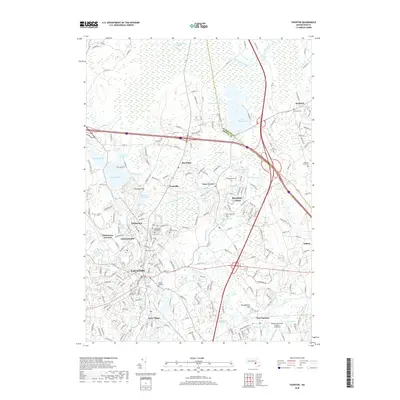
2018 Map of Taunton
USGS Topo · Published 2018About this map
Taunton and its northern neighbors serve as the focal point of this 2018 survey, where the Taunton River and Mill River weave through a densely developed landscape of historic industrial villages. Modern infrastructure like I-495 and MA-24 intersects an older pattern of settlement seen in the clusters of Whittenton, Britanniaville, and Weir Village. The geography is defined by a significant presence of water and wetlands, ranging from the expansive Hockomock Swamp in the north to numerous glacial ponds like Lake Sabbatia and Lake Nippenicket. Local heritage is preserved in sites such as Saint Marys Cem and the Mayflower Hill Sch, while the Taunton Municipal Airport King Field occupies the southeast. The interplay between the river valleys and high ground, including Prospect Hill and Squawbetty Hill, illustrates the enduring physical layout of these Bristol County communities.
Find a feature on this map
60 named features on this map. Tap any name to fly to it.
Don’t see what you’re looking for? This feature index may not catch every label — zoom into the map to look around manually.
Map Details
Editions of this 2018 Taunton Map
This is the sole edition of this map. No revisions or reprints were ever made.
Other maps of this area

1885 · Abington
USGS Topo · 1:62,500

1885 · Middleboro
USGS Topo · 1:62,500

1885 · Taunton
USGS Topo · 1:62,500

1886 · Dedham
USGS Topo · 1:62,500

1888 · Taunton
USGS Topo · 1:62,500

1888 · Middleboro
USGS Topo · 1:62,500

1888 · Abington
USGS Topo · 1:62,500

1893 · Abington
USGS Topo · 1:62,500

1893 · Taunton
USGS Topo · 1:62,500

1893 · Middleboro
USGS Topo · 1:62,500