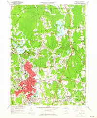
1962 Map of Taunton
USGS Topo · Published 1964About this map
Taunton and its surrounding industrial and agricultural landscape are defined here by a dense network of waterways and early institutional landmarks. The Taunton River and Mill River anchor the urban core, which transitioned from its early manufacturing roots into a regional hub for healthcare and education, as seen by the extensive grounds of the Taunton State Hospital and the Dever State School. To the north, the massive Hockmock Swamp and Titicut Swamp press against the edges of settlements like Raynham, where Cranberry Bogs signal a long-standing local industry.
Find a feature on this map
120 named features on this map. Tap any name to fly to it.
Don’t see what you’re looking for? This feature index may not catch every label — zoom into the map to look around manually.
Map Details
Editions of this 1962 Taunton Map
This is the sole edition of this map. No revisions or reprints were ever made.
Other maps of this area

1885 · Abington
USGS Topo · 1:62,500

1885 · Middleboro
USGS Topo · 1:62,500

1885 · Taunton
USGS Topo · 1:62,500

1886 · Dedham
USGS Topo · 1:62,500

1888 · Taunton
USGS Topo · 1:62,500

1888 · Middleboro
USGS Topo · 1:62,500

1888 · Abington
USGS Topo · 1:62,500

1893 · Abington
USGS Topo · 1:62,500

1893 · Taunton
USGS Topo · 1:62,500

1893 · Middleboro
USGS Topo · 1:62,500