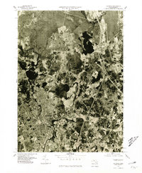
1977 Map of Taunton
USGS Topo · Published 1981About this map
Taunton and its surrounding villages are captured in this 1977 orthophotograph, providing a detailed look at the urban and residential density of Bristol County in the late 1970s. The imagery reveals the winding course of the Taunton River as it passes through the southern portion of the city and near East Taunton. To the north, the landscape transitions into a mosaic of woodland and clearings around Raynham and Raynham Center. The prominent dark expanse of Lake Nippenicket stands out as a major landmark near the community of Scotland, with the Town River feeding into the northern reaches of the quadrangle. This aerial record is particularly useful for observing mid-century suburban expansion and the preservation of industrial-era street grids before more recent developments altered the local character.
Find a feature on this map
8 named features on this map. Tap any name to fly to it.
Don’t see what you’re looking for? This feature index may not catch every label — zoom into the map to look around manually.
Map Details
Editions of this 1977 Taunton Map
This is the sole edition of this map. No revisions or reprints were ever made.
Other maps of this area

1885 · Abington
USGS Topo · 1:62,500

1885 · Middleboro
USGS Topo · 1:62,500

1885 · Taunton
USGS Topo · 1:62,500

1886 · Dedham
USGS Topo · 1:62,500

1888 · Taunton
USGS Topo · 1:62,500

1888 · Middleboro
USGS Topo · 1:62,500

1888 · Abington
USGS Topo · 1:62,500

1893 · Abington
USGS Topo · 1:62,500

1893 · Taunton
USGS Topo · 1:62,500

1893 · Middleboro
USGS Topo · 1:62,500