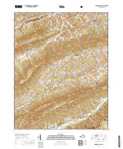
2019 Map of Tazewell South
USGS Topo · Published 2019About this map
Tazewell County Courthouse stands as the central landmark for the town of Tazewell, situated at the convergence of several major regional routes including the Trl of the Lonesome Pine and Fincastle Tpke. The map illustrates a landscape where agricultural valleys and high mountain ridges dictate the settlement patterns of southwestern Virginia. The Witten Valley and the expansive Thompson Valley are clearly defined by the parallel ridges of Paint Lick Mtn, Rich Mtn, and Knob Mtn.
Find a feature on this map
103 named features on this map. Tap any name to fly to it.
Don’t see what you’re looking for? This feature index may not catch every label — zoom into the map to look around manually.
Map Details
Editions of this 2019 Tazewell South Map
This is the sole edition of this map. No revisions or reprints were ever made.
Other maps of this area

1887 · Pocahontas
USGS Topo · 1:125,000

1889 · Wytheville
USGS Topo · 1:125,000

1891 · Tazewell
USGS Topo · 1:125,000

1891 · Pocahontas
USGS Topo · 1:125,000

1891 · Abingdon
USGS Topo · 1:125,000

1892 · Wytheville
USGS Topo · 1:125,000

1894 · Pocahontas
USGS Topo · 1:125,000

1894 · Abingdon
USGS Topo · 1:125,000

1895 · Tazewell
USGS Topo · 1:125,000

1895 · Pocahontas
USGS Topo · 1:125,000