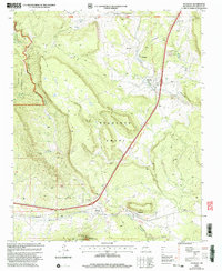
2002 Map of Tecolote
USGS Topo · Published 2003About this map
The Tecolote Grant and Las Vegas Grant define the complex historical land boundaries of this San Miguel County landscape. Following the path of the Santa Fe National Historic Trail, the map documents a corridor of long-standing settlements that emerged along the transportation route and the drainage of Tecolote Creek. Small communities and distinct locales such as Bernal, Serafina, Chapelle, and the Santa Ana (Site) are captured alongside topographic landmarks like Starvation Peak. The terrain is marked by high mesas and deep canyons, including Tres Hermanos Cañon and Cañon Pino Real, within the Santa Fe National Forest. This 2002 revision provides a detailed look at the rural infrastructure of northern New Mexico, from local Grave sites and Cem locations to the network of unimproved roads and landing strips that serve these isolated mountain valleys.
Find a feature on this map
33 named features on this map. Tap any name to fly to it.
Don’t see what you’re looking for? This feature index may not catch every label — zoom into the map to look around manually.
Map Details
Editions of this 2002 Tecolote Map
This is the sole edition of this map. No revisions or reprints were ever made.
Other maps of this area

1889 · Las Vegas
USGS Topo · 1:125,000

1890 · Bernal
USGS Topo · 1:125,000

1891 · Bernal
USGS Topo · 1:125,000

1891 · Las Vegas
USGS Topo · 1:125,000

1893 · Las Vegas
USGS Topo · 1:125,000

1894 · Bernal
USGS Topo · 1:125,000

1954 · Santa Fe
USGS Topo · 1:250,000

1958 · Santa Fe
USGS Topo · 1:250,000

1960 · Villanueva
USGS Topo · 1:62,500

1960 · Apache Springs
USGS Topo · 1:62,500