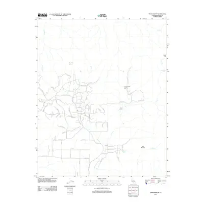
2012 Map of Tehachapi NE
USGS Topo · Published 2012About this map
Sugarloaf Mountain and the high desert peaks of eastern Kern County define this landscape, where the Sierra Nevada meets the Tehachapi Mountains. This 2012 survey captures a period of residential expansion into the canyon bottoms, evidenced by a dense network of suburban streets such as Westhaven Dr, Quail Mountain Rd, and Sand Canyon Rd winding through the difficult terrain. Despite this modern footprint, the map reveals the persistence of the older natural landscape, including the Horse Canyon Agate Beds and seasonal water sources like Goodwater Spring and Sweetwater Spring. The intricate drainage patterns of Cache Cr, Sand Cr, and Stevenson Cr highlight the region's reliance on canyon topography for both settlement and water management. High points like Cache Peak and Red Mountain provide geographic anchors for the developing community in Oil Canyon.
Find a feature on this map
72 named features on this map. Tap any name to fly to it.
Don’t see what you’re looking for? This feature index may not catch every label — zoom into the map to look around manually.
Map Details
Editions of this 2012 Tehachapi NE Map
This is the sole edition of this map. No revisions or reprints were ever made.
Other maps of this area
1915 · Mojave
USGS Topo · 1:125,000
1943 · Tehachapi
USGS Topo · 1:62,500
1943 · Cross Mountain
USGS Topo · 1:62,500
1943 · Emerald Mtn
USGS Topo · 1:62,500
1943 · Mojave
USGS Topo · 1:62,500
1947 · Mojave
USGS Topo · 1:24,000
1948 · Bakersfield
USGS Topo · 1:250,000
1955 · Bakersfield
USGS Topo · 1:250,000
1956 · Bakersfield
USGS Topo · 1:250,000
1956 · Mojave
USGS Topo · 1:62,500