
1943 Map of Mojave
USGS Topo · Published 1943About this map
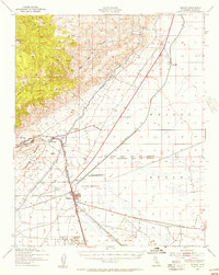
Mojave serves as the central hub of this 1943 survey, situated at the critical junction where the Southern Pacific and Atchison Topeka and Santa Fe railroads meet. The landscape is defined by the stark transition from the high peaks of the Tehachapi Mountains and Cache Peak down into the expansive Mojave Desert. Infrastructure critical to California's growth is prominent, most notably the Los Angeles Aqueduct snaking across the terrain and the Pine Tree Aqueduct Station.
Find a feature on this map
24 named features on this map. Tap any name to fly to it.
Don’t see what you’re looking for? This feature index may not catch every label — zoom into the map to look around manually.
Map Details
Editions of this 1943 Mojave Map
2 editions found
Other maps of this area

1915 · Elizabeth Lake
USGS Topo · 1:125,000

1915 · Searles Lake
USGS Topo · 1:250,000

1915 · Mojave
USGS Topo · 1:125,000

1917 · Elizabeth Lake
USGS Topo · 1:125,000

1937 · Rogers Lake
USGS Topo · 1:48,000

1942 · Rogers Lake
USGS Topo · 1:62,500

1943 · Rosamond
USGS Topo · 1:62,500

1943 · Tehachapi
USGS Topo · 1:62,500

1943 · Cross Mountain
USGS Topo · 1:62,500

1943 · Emerald Mtn
USGS Topo · 1:62,500