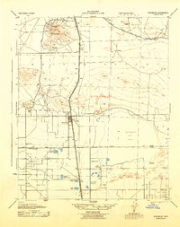
1943 Map of Rosamond
USGS Topo · Published 1943About this map
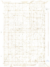
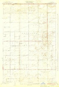
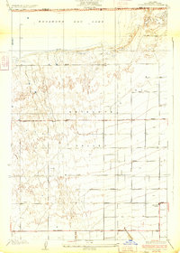
Soledad Mountain rises as a prominent landmark in this high desert landscape, serving as a hub for extensive mining operations during the early 1940s. The northern reaches of the map reveal a cluster of active workings including the Golden Queen Mine, Bobtail Mines, and the Double Eagle Mine, marking the industrial importance of the area near Gold Town. The Southern Pacific railroad cuts a straight line through the center of the sheet, connecting the settlement of Rosamond to outlying stations like Ansel and Gloster. To the east, the vast expanse of Rosamond Dry Lake dominates the terrain, while the southern portion transitions into agricultural and recreational land. This region is characterized by specialized tracts such as Rainbow Farms and several private clubs, including the Piute Gun Club and Glendale Rod & Gun Club, illustrating the diverse land use at the Kern County and Los Angeles County line.
Find a feature on this map
44 named features on this map. Tap any name to fly to it.
Don’t see what you’re looking for? This feature index may not catch every label — zoom into the map to look around manually.
Map Details
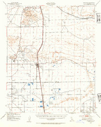
Editions of this 1943 Rosamond Map
2 editions found
Other maps of this area

1915 · Elizabeth Lake
USGS Topo · 1:125,000

1915 · Searles Lake
USGS Topo · 1:250,000

1915 · Mojave
USGS Topo · 1:125,000

1917 · Elizabeth Lake
USGS Topo · 1:125,000

1930 · Oban
USGS Topo · 1:24,000
1930 · Roosevelt School
USGS Topo · 1:24,000
1930 · Casa Desierta
USGS Topo · 1:24,000
1931 · Esperanza School
USGS Topo · 1:24,000
1933 · Casa Desierta
USGS Topo · 1:24,000
1933 · Roosevelt School
USGS Topo · 1:24,000