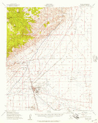
1956 Map of Mojave
USGS Topo · Published 1957About this map
The town of Mojave sits at the critical junction of the Southern Pacific and the Atchison Topeka and Santa Fe railroads, serving as a gateway between the desert flats and the rising Tehachapi Mountains. This mid-century landscape is heavily defined by military and infrastructure projects, featuring the sprawling Marine Corps Auxiliary Air Station and Myer Field, alongside a significant Naval Reservation to the east. The technological footprint of the era is evident in the course of the Los Angeles Aqueduct, which skirts the Horned Toad Hills and the Barren Ridge. Away from the main rail hub, smaller settlements like Reefer City, Neuralia, and Chaffee dot the arid terrain. The high country to the west, marked by Cache Peak and Middle Knob, contains vital water sources like Golden Oaks Spring and Weldon Pond, which historically supported movement through the rugged Jawbone canyon area.
Find a feature on this map
48 named features on this map. Tap any name to fly to it.
Don’t see what you’re looking for? This feature index may not catch every label — zoom into the map to look around manually.
Map Details
Editions of this 1956 Mojave Map
3 editions found
Other maps of this area

1915 · Elizabeth Lake
USGS Topo · 1:125,000

1915 · Searles Lake
USGS Topo · 1:250,000

1915 · Mojave
USGS Topo · 1:125,000

1917 · Elizabeth Lake
USGS Topo · 1:125,000

1937 · Rogers Lake
USGS Topo · 1:48,000

1942 · Rogers Lake
USGS Topo · 1:62,500

1943 · Rosamond
USGS Topo · 1:62,500

1943 · Tehachapi
USGS Topo · 1:62,500

1943 · Cross Mountain
USGS Topo · 1:62,500

1943 · Emerald Mtn
USGS Topo · 1:62,500