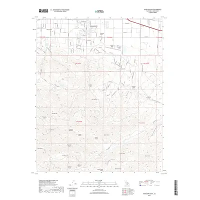
2018 Map of Tehachapi South
USGS Topo · Published 2018About this map
Tehachapi sits at the northern edge of this high-altitude landscape, where the southern reaches of the Sierra Nevada meet the expansive Mojave Desert. The map reveals a transition from the residential street grids of the Tehachapi Valley to the steep, canyon-riven slopes of the Tehachapi Mountains. Significant peaks like Tehachapi Mtn and Double Mtn dominate the central terrain, while aviation activity is anchored by the Mountain Valley Airport. The southern half of the sheet is defined by deep drainage systems including Tejon Canyon, Bean Canyon, and Horsethief Canyon. This area historically served as a critical passage between the Central Valley and the desert, a role evidenced by the crossing at Oak Creek Pass. Small water sources such as Indian John Spring and Gamble Spring are scattered across these arid elevations, providing vital points of reference in a landscape of high ridges and secluded valleys like Paradise Valley.
Find a feature on this map
120 named features on this map. Tap any name to fly to it.
Don’t see what you’re looking for? This feature index may not catch every label — zoom into the map to look around manually.
Map Details
Editions of this 2018 Tehachapi South Map
This is the sole edition of this map. No revisions or reprints were ever made.
Other maps of this area

1903 · Tejon
USGS Topo · 1:125,000

1914 · Caliente
USGS Topo · 1:125,000

1915 · Elizabeth Lake
USGS Topo · 1:125,000

1915 · Mojave
USGS Topo · 1:125,000

1917 · Elizabeth Lake
USGS Topo · 1:125,000

1943 · Tehachapi
USGS Topo · 1:62,500

1943 · Cummings Mountain
USGS Topo · 1:62,500

1943 · Neenach
USGS Topo · 1:62,500

1943 · Willow Springs
USGS Topo · 1:62,500

1948 · Bakersfield
USGS Topo · 1:250,000