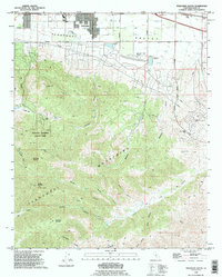
1992 Map of Tehachapi South
USGS Topo · Published 1995About this map
The southern portion of Tehachapi and the surrounding high desert terrain are documented here just as the region transitioned through the late twentieth century. In the Tehachapi Valley, the infrastructure of growth is visible through a network of pipelines, substations, and the Mountain Valley Airport, while the steep southern canyons remain largely defined by their industrial and ranching history. To the south, the Tehachapi Mountains rise sharply, punctuated by family-named landmarks and old extraction sites like the Uncle Sam Mine and Pine Tree Mine. These mountain heights, including the nearly 8,000-foot Tehachapi Mountain, are deeply carved by drainages such as Sawmill Canyon and Oak Creek Canyon, where seasonal water sources like Indian John Spring and numerous unnamed wells sustained local operations. The map also highlights recreational and conservation areas, specifically Tehachapi Mountain County Park, providing a record of land use before more modern residential expansion into these foothills.
Find a feature on this map
55 named features on this map. Tap any name to fly to it.
Don’t see what you’re looking for? This feature index may not catch every label — zoom into the map to look around manually.
Map Details
Editions of this 1992 Tehachapi South Map
This is the sole edition of this map. No revisions or reprints were ever made.
Other maps of this area

1903 · Tejon
USGS Topo · 1:125,000

1914 · Caliente
USGS Topo · 1:125,000

1915 · Elizabeth Lake
USGS Topo · 1:125,000

1915 · Mojave
USGS Topo · 1:125,000

1917 · Elizabeth Lake
USGS Topo · 1:125,000

1943 · Tehachapi
USGS Topo · 1:62,500

1943 · Cummings Mountain
USGS Topo · 1:62,500

1943 · Neenach
USGS Topo · 1:62,500

1943 · Willow Springs
USGS Topo · 1:62,500

1948 · Bakersfield
USGS Topo · 1:250,000