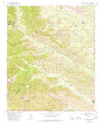
1955 Map of Telegraph Peak
USGS Topo · Published 1980About this map
Wrightwood sits at the edge of the Swarthout Valley, serving as a gateway to the high-elevation terrain of the San Gabriel Mountains. This mid-century survey reveals a landscape shaped by both geologic forces and mountain recreation, dominated by the prominent San Andreas Rift Zone slicing through Lone Pine Canyon. The map details a network of early mountain infrastructure, including the Angeles Crest Highway and several high-altitude landmarks like Telegraph Peak and Thunder Mtn. Scattered across the foothills and canyons are several private holdings such as Nuss Ranch, Prudhon Ranch, and Sharpless Ranch, which represent the early residential and agricultural footprint in this rugged area. Recreational development is evident near Baldy Notch with the presence of a Ski Lift and Miners Bowl, while the Pioneer Historic Marker in Cajon Canyon notes the area's significance for early travelers.
Find a feature on this map
46 named features on this map. Tap any name to fly to it.
Don’t see what you’re looking for? This feature index may not catch every label — zoom into the map to look around manually.
Map Details
Editions of this 1955 Telegraph Peak Map
This is the sole edition of this map. No revisions or reprints were ever made.
Other maps of this area

1896 · San Bernardino
USGS Topo · 1:62,500

1897 · Cucamonga
USGS Topo · 1:62,500

1898 · San Bernardino
USGS Topo · 1:62,500

1900 · Cucamonga
USGS Topo · 1:62,500

1901 · Southern California Sheet No. 1
USGS Topo · 1:250,000

1901 · San Bernardino
USGS Topo · 1:62,500

1902 · Hesperia
USGS Topo · 1:62,500

1903 · Cucamonga
USGS Topo · 1:62,500

1903 · San Antonio
USGS Topo · 1:62,500

1904 · Southern California Sheet No. 1
USGS Topo · 1:250,000