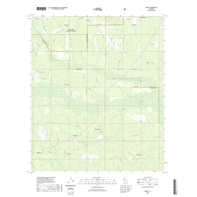
2020 Map of Temple
USGS Topo · Published 2020About this map
Kisatchie National Forest covers much of this Central Louisiana landscape, where the borders of Natchitoches, Rapides, and Vernon Parishes meet. The settlement of Temple lies at the heart of a network of local roads such as Parish Rd 45 and Parish Rd 55, surrounded by numerous watercourses including Bayou Celestine and Comrade Cr. To the north, the community of Mora is situated near the Natchitoches and Vernon Parish line, while Simpson anchors the southwestern corner of the sheet. Genealogy researchers will find several well-documented burial sites throughout the terrain, specifically Comrade Cem, Schorn Brook Cem, and Blackwell Cem. The map illustrates a region defined by its creek systems, such as Middle Cr and Shinglemill Br, which weave through the forested sections and small rural settlements like Burnstown and Pine Coupee.
Find a feature on this map
77 named features on this map. Tap any name to fly to it.
Don’t see what you’re looking for? This feature index may not catch every label — zoom into the map to look around manually.
Map Details
Editions of this 2020 Temple Map
This is the sole edition of this map. No revisions or reprints were ever made.
Other maps of this area

1937 · Chopin NE
USGS Topo · 1:31,680

1937 · Chopin SW
USGS Topo · 1:31,680

1937 · Chopin NW
USGS Topo · 1:31,680

1937 · Chopin SE
USGS Topo · 1:31,680

1941 · Slagle
USGS Topo · 1:62,500

1942 · Kisatchie
USGS Topo · 1:62,500

1943 · Leander
USGS Topo · 1:62,500

1943 · Kisatchie
USGS Topo · 1:62,500

1944 · Chopin
USGS Topo · 1:62,500

1944 · Slagle
USGS Topo · 1:62,500