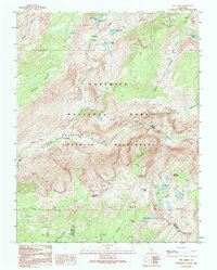
1992 Map of Ten Lakes
USGS Topo · Published 1995About this map
Grand Canyon of the Tuolumne River dominates the central landscape of this 1990s survey, showing the dramatic descent of the Tuolumne River through the Yosemite Wilderness. The map reveals a complex network of high-elevation waterways and peaks, including the titular Ten Lakes cluster tucked behind Ten Lakes Pass and the isolated waters of Grant Lakes further south. The terrain is marked by significant topographical landmarks such as Colby Mountain and Double Rock, which tower over the deep incision of the Tuolumne Gorge.
Find a feature on this map
32 named features on this map. Tap any name to fly to it.
Don’t see what you’re looking for? This feature index may not catch every label — zoom into the map to look around manually.
Map Details
Editions of this 1992 Ten Lakes Map
This is the sole edition of this map. No revisions or reprints were ever made.
Other maps of this area

1896 · Dardanelles
USGS Topo · 1:125,000

1897 · Yosemite
USGS Topo · 1:125,000

1898 · Dardanelles
USGS Topo · 1:125,000

1900 · Yosemite
USGS Topo · 1:125,000

1901 · Mt. Lyell
USGS Topo · 1:125,000

1903 · Yosemite
USGS Topo · 1:125,000

1909 · Yosemite
USGS Topo · 1:125,000

1909 · Bridgeport
USGS Topo · 1:125,000

1911 · Bridgeport
USGS Topo · 1:125,000

1920 · Bridgeport
USGS Topo · 1:125,000