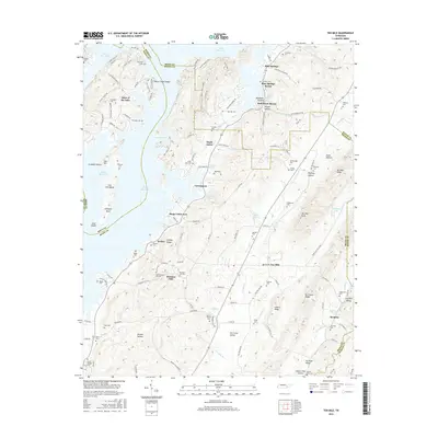
2016 Map of Ten Mile
USGS Topo · Published 2016About this map
Watts Bar Lake dominates the western half of this quadrangle, where the waters of the Tennessee River basin submerge the historic White Creek Shoals and create landmarks like Pearl Harbor and Iron Hill Island. The eastern landscape is defined by the ridgelines and hollows of the Ridge-and-Valley Appalachians, including Ten Mile Ridge and No Pone Ridge. This topography has historically funneled settlement into pockets like Ten Mile and Maple Grove. For genealogists, the map is a dense record of family history, preserving the locations of numerous burial grounds such as Old Pleasant Hill Cem, Roark Cemetery, and the Deatherage Cem. The intersection of multiple counties—Meigs, Roane, Rhea, and McMinn—highlights the area's importance as a regional borderland shaped by the Tennessee Valley Authority’s mid-century influence on the local landscape.
Find a feature on this map
146 named features on this map. Tap any name to fly to it.
Don’t see what you’re looking for? This feature index may not catch every label — zoom into the map to look around manually.
Map Details
Editions of this 2016 Ten Mile Map
This is the sole edition of this map. No revisions or reprints were ever made.
Other maps of this area

1887 · Kingston
USGS Topo · 1:125,000

1891 · Kingston
USGS Topo · 1:125,000

1893 · Kingston
USGS Topo · 1:125,000

1935 · Niota
USGS Topo · 1:24,000

1935 · Rockwood
USGS Topo · 1:24,000

1935 · Decatur
USGS Topo · 1:24,000

1936 · Roddy
USGS Topo · 1:24,000

1936 · Spring City
USGS Topo · 1:24,000
1936 · Pattie Gap
USGS Topo · 1:24,000
1936 · Ten Mile
USGS Topo · 1:24,000