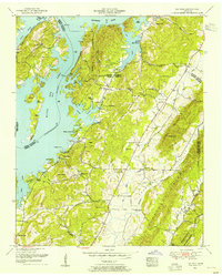
1952 Map of Ten Mile
USGS Topo · Published 1954About this map
Watts Bar Lake dominates the western landscape of this 1952 study, its fingers reaching into deep hollows such as Possumtrot Hollow and Dada Hollow. This postwar era shows the area transitioning under the influence of the Tennessee Valley Authority, with the shoreline of the Tennessee River reshaped by the damming of Gillespie Bend. The interior remains deeply rural and family-centered, evidenced by an exceptional density of private burial grounds like Culvahouse Cemetery, Deatherage Cemetery, and Hornsby Cemetery. The village of Ten Mile serves as a small crossroads hub near Ten Mile School, while unique landmarks like the Indian mounds near Cane Creek and an Abandoned silo provide tangible physical history of both ancient and early twentieth-century land use. Scattered houses of worship, including Euchee Chapel and Maple Grove Church, anchor these small agrarian communities across the ridgelines of Ten Mile Ridge.
Find a feature on this map
67 named features on this map. Tap any name to fly to it.
Don’t see what you’re looking for? This feature index may not catch every label — zoom into the map to look around manually.
Map Details
Editions of this 1952 Ten Mile Map
This is the sole edition of this map. No revisions or reprints were ever made.
Other maps of this area

1887 · Kingston
USGS Topo · 1:125,000

1891 · Kingston
USGS Topo · 1:125,000

1893 · Kingston
USGS Topo · 1:125,000

1935 · Niota
USGS Topo · 1:24,000

1935 · Rockwood
USGS Topo · 1:24,000

1935 · Decatur
USGS Topo · 1:24,000

1936 · Roddy
USGS Topo · 1:24,000

1936 · Spring City
USGS Topo · 1:24,000
1936 · Pattie Gap
USGS Topo · 1:24,000
1936 · Ten Mile
USGS Topo · 1:24,000