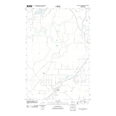
2011 Map of Tenalquot Prairie
USGS Topo · Published 2011About this map
Rainier anchors the southern portion of this landscape, situated at the edge of the Tenalquot Prairie. The area is defined by a dense network of glacial lakes and wetlands, including Lake Saint Clair to the north and a cluster of smaller bodies like Fiander Lake, McEnniery Lake, and the Cat Lakes. To the northeast, the map shows the boundary of Fort Lewis where the Nisqually River flows near the Oxbow Lake Dam. The road network reflects recent growth and military history, featuring routes such as Military Rd and the uniquely named 205th AAA Battalion Rd SE, which likely relates to historical anti-aircraft artillery deployments. The terrain transitions from the prairie floor to more wooded reaches along Eaton Creek and the Deschutes River, with rural outposts like Burnham Ranch providing landmarks in the eastern fields.
Find a feature on this map
85 named features on this map. Tap any name to fly to it.
Don’t see what you’re looking for? This feature index may not catch every label — zoom into the map to look around manually.
Map Details
Editions of this 2011 Tenalquot Prairie Map
This is the sole edition of this map. No revisions or reprints were ever made.
Other maps of this area

1916 · Chehalis
USGS Topo · 1:125,000

1937 · Olympia
USGS Topo · 1:62,500

1940 · Tenino
USGS Topo · 1:62,500

1940 · Anderson Island
USGS Topo · 1:62,500

1944 · Tenino
USGS Topo · 1:62,500

1944 · Yelm
USGS Topo · 1:62,500

1948 · Anderson Island
USGS Topo · 1:62,500

1948 · Fort Lewis
USGS Topo · 1:24,000

1948 · Nisqually
USGS Topo · 1:24,000

1949 · Yelm
USGS Topo · 1:62,500