1949 Map of Yelm
USGS Topo · Published 1958About this map
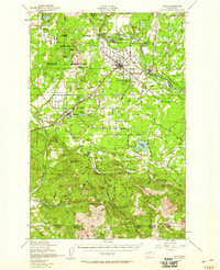
Yelm serves as a central hub at the intersection of various prairie landscapes and expanding infrastructure in the late 1940s. The northern portion of this survey is dominated by the Fort Lewis Military Reservation, featuring the Rainier Training Area and several abandoned targets. The Nisqually River carves through the terrain, feeding the Yelm Canal and passing the Centralia Power Plant. Settlement patterns are defined by wide, named plains like Weir Prairie and Smith Prairie, where agriculture and timber interests are evident through features like Reichel Ranch and the logging community of Vail. A complex rail network including the Northern Pacific and a Military Railroad illustrates the strategic and economic importance of this corridor between McKenna and Rainier. Further south, the landscape rises into the timbered heights of Porcupine Ridge and Clam Mountain, monitored by fire lookouts such as the Porcupine Lookout.
Find a feature on this map
70 named features on this map. Tap any name to fly to it.
Don’t see what you’re looking for? This feature index may not catch every label — zoom into the map to look around manually.
Map Details
Editions of this 1949 Yelm Map
This is the sole edition of this map. No revisions or reprints were ever made.
Other maps of this area

1897 · Tacoma
USGS Topo · 1:125,000

1900 · Tacoma
USGS Topo · 1:125,000

1916 · Chehalis
USGS Topo · 1:125,000

1937 · Olympia
USGS Topo · 1:62,500

1937 · Eatonville
USGS Topo · 1:125,000

1940 · Tenino
USGS Topo · 1:62,500

1940 · Anderson Island
USGS Topo · 1:62,500

1941 · Tanwax Lake
USGS Topo · 1:62,500

1941 · Tacoma South
USGS Topo · 1:62,500

1943 · Willapa
USGS Topo · 1:62,500