1949 Map of Tenino
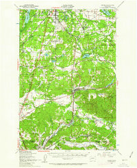
USGS Topo · Published 1962About this map
The Deschutes River and Skookumchuck River define the drainage of this South Sound landscape, where glacial prairies meet the timbered foothills of the Cascades. Post-war development centers on Tenino and Bucoda, connected by a dense network of major rail lines including the Great Northern and Union Pacific. The presence of the Oregon Trail Monument near Bushman Lake highlights the region's significance to early westward migration, while the Fort Lewis Military Reservation occupies a large portion of the northeast, reflecting the military's expanding footprint during this era.
Find a feature on this map
72 named features on this map. Tap any name to fly to it.
Don’t see what you’re looking for? This feature index may not catch every label — zoom into the map to look around manually.
Map Details
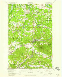
Editions of this 1949 Tenino Map
2 editions found
Other maps of this area

1916 · Chehalis
USGS Topo · 1:125,000

1937 · Olympia
USGS Topo · 1:62,500

1939 · Shelton
USGS Topo · 1:62,500

1940 · Tenino
USGS Topo · 1:62,500

1940 · Anderson Island
USGS Topo · 1:62,500

1941 · Meskill
USGS Topo · 1:62,500

1941 · Gate
USGS Topo · 1:62,500

1943 · Willapa
USGS Topo · 1:62,500

1944 · Tenino
USGS Topo · 1:62,500

1944 · Yelm
USGS Topo · 1:62,500