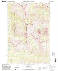
1998 Map of Tenmile Lake
USGS Topo · Published 2002About this map
The Selway Bitterroot Wilderness dominates this 1990s landscape, spanning the rugged divide where Ravalli and Idaho counties meet. This high-altitude terrain is defined by the sharp transition between the Nez Perce National Forest and the Bitterroot National Forest, where steep drainages and glacial lakes carve out the western Montana and eastern Idaho border. The map documents the intricate hydrology of the region, from the headwaters of Roaring Lion Creek to the deep basins holding Tenmile Lake and Twin Lakes.
Find a feature on this map
27 named features on this map. Tap any name to fly to it.
Don’t see what you’re looking for? This feature index may not catch every label — zoom into the map to look around manually.
Map Details
Editions of this 1998 Tenmile Lake Map
This is the sole edition of this map. No revisions or reprints were ever made.
Other maps of this area

1901 · Hamilton
USGS Topo · 1:125,000

1911 · Lolo
USGS Topo · 1:250,000

1913 · Lolo
USGS Topo · 1:250,000

1956 · Hamilton
USGS Topo · 1:250,000

1959 · Hamilton
USGS Topo · 1:250,000

1960 · Hamilton
USGS Topo · 1:250,000

1964 · Hamilton
USGS Topo · 1:250,000

1964 · Tenmile Lake
USGS Topo · 1:24,000

1964 · Ward Mountain
USGS Topo · 1:24,000
1964 · El Capitan
USGS Topo · 1:24,000