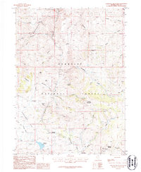
1986 Map of Tennessee Mountain
USGS Topo · Published 1987About this map
Humboldt National Forest encompasses this high-elevation landscape in Elko County, where the mining and ranching heritage of Nevada is clearly etched into the terrain. The 1980s landscape is defined by its water sources and geological features, from the Sunflower Reservoir in the southwest to the numerous named springs such as Bieroth Spring and Big Coffeepot Spring. The presence of the Gold Creek Ranger Station and various Campground sites indicates the area's transition into a managed recreational and administrative zone, while the underlying resource economy remains visible through operations like the Wildhorse Mine and Diamond Jim Mine.
Find a feature on this map
46 named features on this map. Tap any name to fly to it.
Don’t see what you’re looking for? This feature index may not catch every label — zoom into the map to look around manually.
Map Details
Editions of this 1986 Tennessee Mountain Map
This is the sole edition of this map. No revisions or reprints were ever made.
Other maps of this area

1935 · Charleston
USGS Topo · 1:48,000

1936 · Mountain City
USGS Topo · 1:62,500

1936 · Rowland
USGS Topo · 1:48,000

1940 · Rowland
USGS Topo · 1:62,500

1940 · Mountain City
USGS Topo · 1:62,500

1942 · Mt. Velma
USGS Topo · 1:62,500

1955 · Wells
USGS Topo · 1:250,000

1956 · Wild Horse
USGS Topo · 1:62,500

1958 · Wells
USGS Topo · 1:250,000

1961 · Wells
USGS Topo · 1:250,000