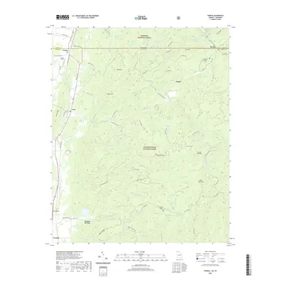
2020 Map of Tennga
USGS Topo · Published 2020About this map
Tennga and the Tennessee-Georgia state line define the northern edge of this North Georgia mountain landscape. The region is largely dominated by the protected timberlands of the Chattahoochee National Forest and Cherokee National Forest, where the terrain is marked by prominent peaks like Peaky Top and the high ridges of Iron Mountain. The Conasauga River and Jacks River flow through the valleys, carving out the Alaculsy Valley and providing the drainage for numerous creeks like Tearbritches Creek and Hickory Creek. Smaller settlements and crossroads such as Cisco, Fairy Valley, and Cohutta Springs are scattered along the western foothills, connected by local routes like Brush Town Road and Lost Silver Mine Road. This contemporary survey details a complex network of forest service roads and recreational paths, including the Sumac Creek Trail and Rocky Flats Atv Trail, illustrating the modern balance between small-town residency and expansive public wilderness.
Find a feature on this map
72 named features on this map. Tap any name to fly to it.
Don’t see what you’re looking for? This feature index may not catch every label — zoom into the map to look around manually.
Map Details
Editions of this 2020 Tennga Map
This is the sole edition of this map. No revisions or reprints were ever made.
Other maps of this area

1886 · Dalton
USGS Topo · 1:125,000

1886 · Cleveland
USGS Topo · 1:125,000

1892 · Cleveland
USGS Topo · 1:125,000

1892 · Dalton
USGS Topo · 1:125,000

1895 · Cleveland
USGS Topo · 1:125,000

1897 · Dalton
USGS Topo · 1:125,000

1901 · Cleveland
USGS Topo · 1:125,000

1911 · Cohutta Mtn
USGS Topo · 1:62,500

1913 · Cohutta Mtn.
USGS Topo · 1:62,500
1935 · Hemp Top
USGS Topo · 1:24,000