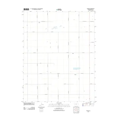
2012 Map of Tennis
USGS Topo · Published 2012About this map
Gano and Tennis appear as small, rural settlements in the high plains of western Kansas in this 2012 survey. The landscape is characterized by a precise grid of agricultural section roads, including N Chmelka Rd and N Sherlock Rd, which dictate the movement across Finney County. While the region is predominantly dry, notable depressions are filled by Sondreagger Lake and Corrigan Lake, providing rare water features in an otherwise uniform terrain. The presence of Crist Airport north of W Sondreagger Rd indicates the importance of private aviation for transport and crop management in this isolated farming district. The map illustrates a modern continuation of the original Homestead Act land divisions, where family-named landmarks like W Wiebe Rd and W Barlow Rd preserve the local history of settlement and property ownership.
Find a feature on this map
26 named features on this map. Tap any name to fly to it.
Don’t see what you’re looking for? This feature index may not catch every label — zoom into the map to look around manually.
Map Details
Editions of this 2012 Tennis Map
This is the sole edition of this map. No revisions or reprints were ever made.
Other maps of this area

1940 · Scott City
USGS Topo · 1:62,500

1941 · Modoc
USGS Topo · 1:62,500

1944 · Tennis
USGS Topo · 1:62,500

1951 · Scott City
USGS Topo · 1:62,500

1951 · Modoc
USGS Topo · 1:62,500

1955 · Scott City
USGS Topo · 1:250,000

1958 · Scott City
USGS Topo · 1:250,000
1965 · Wolf
USGS Topo · 1:24,000

1965 · Wolf NE
USGS Topo · 1:24,000
1976 · Lowe
USGS Topo · 1:24,000