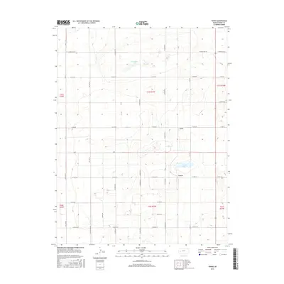
2015 Map of Tennis
USGS Topo · Published 2015About this map
Tennis and Gano anchor this section of Finney County, illustrating the high-plains settlement pattern of small community centers defined by a grid of named roads. The landscape is marked by natural depressions such as Sondregger Lake and Corrigan Lake, which provide rare water sources in an otherwise structured agricultural layout. The dominance of section-line roads like W Sondregger Rd, N Chmelka Rd, and Big Lowe Rd reflects the influence of the Public Land Survey System on Kansas development. This 2015 update, produced by the U.S. Geological Survey, captures the continuity of rural life where local family names, preserved in labels like Anderson Rd, remain central to the geography.
Find a feature on this map
33 named features on this map. Tap any name to fly to it.
Don’t see what you’re looking for? This feature index may not catch every label — zoom into the map to look around manually.
Map Details
Editions of this 2015 Tennis Map
This is the sole edition of this map. No revisions or reprints were ever made.
Other maps of this area

1940 · Scott City
USGS Topo · 1:62,500

1941 · Modoc
USGS Topo · 1:62,500

1944 · Tennis
USGS Topo · 1:62,500

1951 · Scott City
USGS Topo · 1:62,500

1951 · Modoc
USGS Topo · 1:62,500

1955 · Scott City
USGS Topo · 1:250,000

1958 · Scott City
USGS Topo · 1:250,000
1965 · Wolf
USGS Topo · 1:24,000

1965 · Wolf NE
USGS Topo · 1:24,000
1976 · Lowe
USGS Topo · 1:24,000