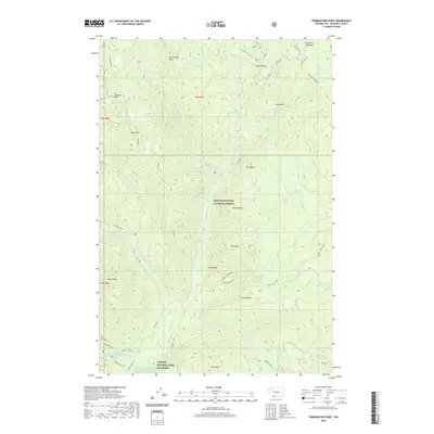
2020 Map of Termination Point
USGS Topo · Published 2020About this map
The Carson National Fish Hatchery and Tyee Springs anchor the southern reaches of this landscape within the Gifford Pinchot National Forest. This 2020 survey documents a complex network of recreational trails and water systems, including the Hard Time Loop, Ski Loop E, and the Terminator trail near McClellan Meadows. The terrain is defined by a series of volcanic and geological landmarks, such as Lava Butte, North Butte, and the namesake Termination Point overlooking the Wind River. Hydrographic features are prominent throughout, ranging from the dramatic Falls Creek Falls to secluded points like Bubbling Mike Spring on Trapper Creek. This map illustrates the contemporary management of these public lands, showing the intersection of forest service infrastructure and the natural drainage basins of Paradise Cr and Ninemile Creek.
Find a feature on this map
49 named features on this map. Tap any name to fly to it.
Don’t see what you’re looking for? This feature index may not catch every label — zoom into the map to look around manually.
Map Details
Editions of this 2020 Termination Point Map
This is the sole edition of this map. No revisions or reprints were ever made.
Other maps of this area

1919 · Mount St Helens
USGS Topo · 1:125,000

1926 · Steamboat Mtn
USGS Topo · 1:125,000

1926 · Hood River
USGS Topo · 1:125,000

1929 · Hood River
USGS Topo · 1:125,000

1931 · Steamboat Mtn
USGS Topo · 1:125,000

1940 · Lookout Mtn
USGS Topo · 1:62,500

1948 · Vancouver
USGS Topo · 1:250,000

1950 · Vancouver
USGS Topo · 1:250,000

1950 · Vancouver
USGS Topo · 1:250,000

1950 · Yakima
USGS Topo · 1:250,000