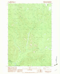
1983 Map of Termination Point
USGS Topo · Published 1983About this map
Gifford Pinchot National Forest dominates this mountain landscape, where the Wind River cuts south past a series of prominent volcanic features including Lava Butte, North Butte, and South Butte. The area is defined by its natural resource history, anchored by the Wind River Mine and the Carson National Fish Hatchery near Tyee Springs. For those tracing local recreation and settlement history, the map details the location of Government Mineral Springs and the nearby Bubbling Mike Spring, alongside higher elevation landmarks like Oldman Pass and McClellan Meadows. Extensive Gravel deposits and a Spoil Bank reflect the industrial and maintenance activity within the forest's interior during the early 1980s. A network of creeks, such as Proverbial Creek and Ninemile Creek, drains the steep slopes of Howe Ridge and the Paradise Hills, illustrating the complex drainage patterns that shaped the region’s topography and access routes.
Find a feature on this map
32 named features on this map. Tap any name to fly to it.
Don’t see what you’re looking for? This feature index may not catch every label — zoom into the map to look around manually.
Map Details
Editions of this 1983 Termination Point Map
This is the sole edition of this map. No revisions or reprints were ever made.
Other maps of this area

1919 · Mount St Helens
USGS Topo · 1:125,000

1926 · Steamboat Mtn
USGS Topo · 1:125,000

1926 · Hood River
USGS Topo · 1:125,000

1929 · Hood River
USGS Topo · 1:125,000

1931 · Steamboat Mtn
USGS Topo · 1:125,000

1940 · Lookout Mtn
USGS Topo · 1:62,500

1948 · Vancouver
USGS Topo · 1:250,000

1950 · Vancouver
USGS Topo · 1:250,000

1950 · Vancouver
USGS Topo · 1:250,000

1950 · Yakima
USGS Topo · 1:250,000