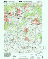
1999 Map of Terre Hill
USGS Topo · Published 2001About this map
The rolling agricultural landscape of northeastern Lancaster County is defined by the convergence of several major watercourses, including Muddy Creek and the Conestoga River. At the turn of the millennium, this area maintained a dense network of small settlements and educational sites, from Adamstown on the ridge to the village of Terre Hill. The map documents a high concentration of local institutions that reflect the region's deep community roots, such as the Muddy Creek Ch and Weaverland Sch.
Find a feature on this map
65 named features on this map. Tap any name to fly to it.
Don’t see what you’re looking for? This feature index may not catch every label — zoom into the map to look around manually.
Map Details
Editions of this 1999 Terre Hill Map
This is the sole edition of this map. No revisions or reprints were ever made.
Other maps of this area

1894 · Reading
USGS Topo · 1:62,500

1902 · Wernersville
USGS Topo · 1:62,500

1905 · Honey Brook
USGS Topo · 1:62,500

1906 · New Holland
USGS Topo · 1:62,500

1907 · Honeybrook
USGS Topo · 1:62,500

1908 · New Holland
USGS Topo · 1:62,500

1913 · Reading
USGS Topo · 1:62,500

1915 · Reading
USGS Topo · 1:62,500

1941 · Honeybrook
USGS Topo · 1:62,500

1941 · New Holland
USGS Topo · 1:62,500