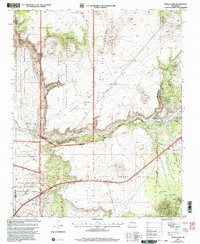
2002 Map of Tetilla Peak
USGS Topo · Published 2003About this map
Tetilla Peak and the volcanic terrain of the Mesa Del Rio Plateau dominate this high-desert landscape south of Santa Fe. The area is defined by a complex intersection of historic land grants and sovereign lands, including the Caja Del Rio Grant, La Majada Grant, and the Santo Domingo Pueblo Grant. The Santa Fe River carves through the basaltic canyon below La Bajada, a location of immense historical significance for travelers on the Camino Real who had to navigate the steep descent here. Along the eastern edge, the settlement of La Cienega sits near the confluence of Cienega Creek, where springs historically supported agriculture. The transition from the high mesa at Tsinat Mesa down to the Rio Grande valley is marked by industrial activity such as the Cinder Pit and several gravel operations near the I-25 corridor.
Find a feature on this map
35 named features on this map. Tap any name to fly to it.
Don’t see what you’re looking for? This feature index may not catch every label — zoom into the map to look around manually.
Map Details
Editions of this 2002 Tetilla Peak Map
This is the sole edition of this map. No revisions or reprints were ever made.
Other maps of this area

1892 · San Pedro
USGS Topo · 1:125,000

1892 · Santa Clara
USGS Topo · 1:125,000

1951 · Agua Fria
USGS Topo · 1:24,000

1951 · Turquoise Hill
USGS Topo · 1:24,000

1952 · Turquoise Hill
USGS Topo · 1:24,000

1952 · Montoso Peak
USGS Topo · 1:24,000

1953 · Cochiti Dam
USGS Topo · 1:24,000

1953 · Santo Domingo Pueblo
USGS Topo · 1:24,000

1953 · Tetilla Peak
USGS Topo · 1:24,000

1953 · Agua Fria
USGS Topo · 1:62,500