
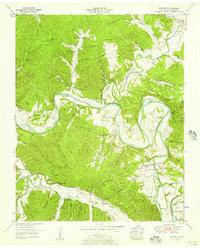
1936 Map of Texas Hollow
USGS Topo · Published 1936About this map
The Piney River meanders through the heart of the Tennessee hills in this 1936 survey, which highlights the rural infrastructure of the era between the Hickman and Dickson county line. The settlement of Pinewood serves as a local hub, supported by the nearby Pinewood Sch and Humble Ch. The map reveals a landscape defined by its hollows—such as Texas Hollow and Chalkbank Hollow—and a dense network of country schools, including Cedar Hill Sch, Plunders Creek Sch, and Big Spring Creek Sch, illustrating the dispersed community structure of pre-war middle Tennessee. Technological transitions are evident along the southern edge of the sheet, where an Emergency Landing Field and Airway Beacon are positioned near the Nashville Chattanooga and St Louis rail line. This proximity of early aviation infrastructure to the established railroad and the local Camp Ground Sch points to a moment of significant transport modernization in an otherwise traditional agrarian setting.
Find a feature on this map
48 named features on this map. Tap any name to fly to it.
Don’t see what you’re looking for? This feature index may not catch every label — zoom into the map to look around manually.
Map Details
Editions of this 1936 Texas Hollow Map
This is the sole edition of this map. No revisions or reprints were ever made.
Other maps of this area

1901 · Colombia
USGS Topo · 1:125,000

1936 · Nunnelly
USGS Topo · 1:24,000

1936 · Whitfield
USGS Topo · 1:24,000

1936 · Littlelot
USGS Topo · 1:24,000

1936 · Spot
USGS Topo · 1:24,000

1936 · Burns
USGS Topo · 1:24,000

1936 · Lyles
USGS Topo · 1:24,000

1936 · Tennessee City
USGS Topo · 1:24,000

1936 · Dickson
USGS Topo · 1:24,000
1952 · Whitfield
USGS Topo · 1:24,000