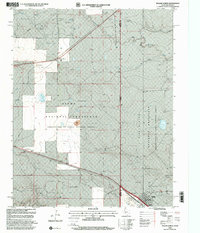
1998 Map of Texline North
USGS Topo · Published 2001About this map
Kiowa National Grassland dominates this High Plains landscape where the Texas Panhandle meets New Mexico. The boundary between Union County and Dallam County aligns with the state line, creating a unique intersection of ranching interests and federal land management. Evidence of the region's agricultural economy is visible at the Clayton Livestock Research Center and the small settlement of Texline, which serves as a critical junction for local rail and road transport.
Find a feature on this map
18 named features on this map. Tap any name to fly to it.
Don’t see what you’re looking for? This feature index may not catch every label — zoom into the map to look around manually.
Map Details
Editions of this 1998 Texline North Map
This is the sole edition of this map. No revisions or reprints were ever made.
Other maps of this area

1954 · Dalhart
USGS Topo · 1:250,000

1958 · Dalhart
USGS Topo · 1:250,000

1962 · Dalhart
USGS Topo · 1:250,000

1969 · Felt SW
USGS Topo · 1:24,000

1970 · Texline South
USGS Topo · 1:24,000

1970 · Clayton
USGS Topo · 1:24,000

1970 · Clayton SW
USGS Topo · 1:24,000

1970 · Texline North
USGS Topo · 1:24,000

1972 · Rardin Hill
USGS Topo · 1:24,000
1972 · Rabbit Ear Mountain
USGS Topo · 1:24,000