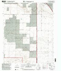
1998 Map of Texline South
USGS Topo · Published 2001About this map
The High Plains borderlands of the Texas Panhandle and New Mexico are defined here by a transition from organized ranching to federally managed conservation. Texline sits at the northern edge of the sheet, where the state line divides Union County and Dallam County. Much of the western terrain is dedicated to the Kiowa National Grassland, while the eastern portion includes sections of the Rita Blanca National Grassland. The landscape is etched by drainage systems like West Rita Blanca Creek, Cardizo Creek, and Sand Draw, punctuated by numerous cattle operations. Ranching infrastructure is a primary feature of the area, evidenced by the Circle H Farms Ltd Airport, various Corrals, and a large Feed Lot near the local Cem. This survey reflects a late 20th-century landscape where agricultural industry and environmental management coexist along the interstate boundary.
Find a feature on this map
16 named features on this map. Tap any name to fly to it.
Don’t see what you’re looking for? This feature index may not catch every label — zoom into the map to look around manually.
Map Details
Editions of this 1998 Texline South Map
This is the sole edition of this map. No revisions or reprints were ever made.
Other maps of this area

1954 · Dalhart
USGS Topo · 1:250,000

1958 · Dalhart
USGS Topo · 1:250,000

1962 · Dalhart
USGS Topo · 1:250,000

1970 · Texline South
USGS Topo · 1:24,000

1970 · Clayton
USGS Topo · 1:24,000

1970 · Clayton SW
USGS Topo · 1:24,000

1970 · Texline North
USGS Topo · 1:24,000

1970 · Sedan
USGS Topo · 1:24,000

1970 · Sedan NE
USGS Topo · 1:24,000

1973 · Corlena
USGS Topo · 1:24,000