
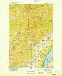
1950 Map of The Brothers
USGS Topo · Published 1950About this map
The Hood Canal shoreline and the high peaks of the Olympic Peninsula meet in this 1950 edition, showing a landscape defined by sharp transitions from saltwater to alpine summits. Along the coast at Eldon, small settlements and the John Ahl Sch occupy the narrow strip between the water and the rising slopes of the Olympic National Forest. Moving inland, the map traces the deep river valleys of the Dosewallips River, Duckabush River, and Hamma Hamma River, which served as the primary conduits for backcountry access before the modernization of the road network.
Find a feature on this map
74 named features on this map. Tap any name to fly to it.
Don’t see what you’re looking for? This feature index may not catch every label — zoom into the map to look around manually.
Map Details
Editions of this 1950 The Brothers Map
2 editions found
Other maps of this area

1936 · Point Misery
USGS Topo · 1:62,500

1938 · Mt Constance
USGS Topo · 1:125,000

1938 · Allyn
USGS Topo · 1:62,500

1940 · Point Misery
USGS Topo · 1:62,500

1940 · Quilcene
USGS Topo · 1:62,500

1943 · Potlatch
USGS Topo · 1:62,500

1944 · Mt. Angeles
USGS Topo · 1:62,500

1946 · Mt. Angeles
USGS Topo · 1:62,500

1946 · Tyler Peak
USGS Topo · 1:62,500

1947 · The Brothers
USGS Topo · 1:62,500