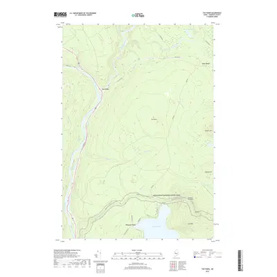
2018 Map of The Forks
USGS Topo · Published 2018About this map
The confluence of the Kennebec River and the Dead River anchors this Somerset County landscape at the village of The Forks. This river junction historically served as a critical hub for Maine’s logging and river-driving industries. Moving east from the valley, the terrain rises sharply toward The Divide and a series of peaks including Pleasant Pond Mtn and Mosquito Mtn. The Appalachian National Scenic Trail winds across the southern portion of the map, crossing over the heights before descending toward the waters of Pleasant Pond. This 2018 survey also tracks the remote road networks established for timber management, such as Lake Moxie RD and Boise RD, which connect the isolated settlement at Lake Moxie with the surrounding highlands. Numerous waterways like Moxie Stream and Holly Brook carve through the heavily forested interior, illustrating the complex drainage patterns of the Kennebec watershed.
Find a feature on this map
38 named features on this map. Tap any name to fly to it.
Don’t see what you’re looking for? This feature index may not catch every label — zoom into the map to look around manually.
Map Details
Editions of this 2018 The Forks Map
This is the sole edition of this map. No revisions or reprints were ever made.
Other maps of this area

1903 · Bingham
USGS Topo · 1:62,500

1905 · Bingham
USGS Topo · 1:62,500

1905 · The Forks
USGS Topo · 1:62,500

1907 · The Forks
USGS Topo · 1:62,500

1925 · Pierce Pond
USGS Topo · 1:48,000

1927 · Pierce Pond
USGS Topo · 1:62,500

1928 · Dead River
USGS Topo · 1:62,500

1931 · Dead River
USGS Topo · 1:48,000

1944 · Dead River
USGS Topo · 1:62,500

1944 · Pierce Pond
USGS Topo · 1:62,500