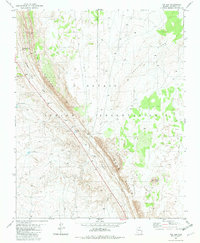
1981 Map of The Gap
USGS Topo · Published 1982About this map
Echo Cliffs dominate this portion of the Navajo Indian Reservation, forming a massive diagonal escarpment that defines the region's geography. The map reveals a land where water is the primary concern for survival and settlement, evidenced by the series of family-named water sources such as Tsin Beskunt Well, Curtis Well, Bodaway Well, and Begay Well. These points of interest are scattered across the arid landscape east and west of the cliffs, often connected only by 4wd tracks.
Find a feature on this map
17 named features on this map. Tap any name to fly to it.
Don’t see what you’re looking for? This feature index may not catch every label — zoom into the map to look around manually.
Map Details
Editions of this 1981 The Gap Map
This is the sole edition of this map. No revisions or reprints were ever made.
Other maps of this area

1886 · Echo Cliffs
USGS Topo · 1:250,000

1891 · Echo Cliffs
USGS Topo · 1:250,000

1954 · Shinumo Altar NE
USGS Topo · 1:24,000

1954 · Shinumo Altar SE
USGS Topo · 1:24,000

1954 · Shinumo Altar
USGS Topo · 1:62,500

1955 · Blue Spring NE
USGS Topo · 1:24,000

1955 · Moa Ave NW
USGS Topo · 1:24,000

1955 · Blue Spring
USGS Topo · 1:62,500

1956 · Marble Canyon
USGS Topo · 1:250,000
1957 · The Gap SW
USGS Topo · 1:24,000