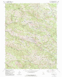
1993 Map of The Geysers
USGS Topo · Published 1993About this map
The Mayacmas Mountains define this industrial and geothermal landscape, where the extraction of earth's energy is mapped alongside its mineral history. Numerous Geothermal Wells and several Power Plants are scattered across the terrain, indicating the intensive development of the area's natural steam resources. These modern facilities operate in the shadow of older industrial sites like the Silver Bear Mine, Buckeye Mine, and Socrates Mine, showing the transition from traditional mining to energy production.
Find a feature on this map
54 named features on this map. Tap any name to fly to it.
Don’t see what you’re looking for? This feature index may not catch every label — zoom into the map to look around manually.
Map Details
Editions of this 1993 The Geysers Map
This is the sole edition of this map. No revisions or reprints were ever made.
Other maps of this area

1920 · Healdsburg
USGS Topo · 1:62,500

1921 · Kelseyville
USGS Topo · 1:62,500

1927 · Calistoga
USGS Topo · 1:62,500

1933 · Healdsburg
USGS Topo · 1:48,000

1940 · Healdsburg
USGS Topo · 1:62,500

1943 · Calistoga
USGS Topo · 1:62,500

1943 · Kelseyville
USGS Topo · 1:62,500

1945 · Calistoga
USGS Topo · 1:62,500

1945 · Lower Lake
USGS Topo · 1:62,500

1947 · Santa Rosa
USGS Topo · 1:250,000