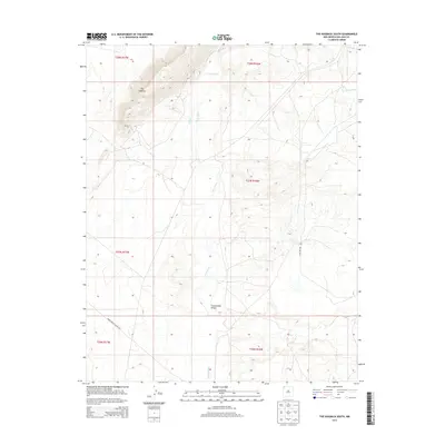
2013 Map of The Hogback South
USGS Topo · Published 2013About this map
The Hogback rises as the dominant geological landmark in this part of the San Juan Basin, its distinctive monocline structure cutting through the desert landscape. The Chaco River meanders across the territory, joined by intermittent drainages such as Coal Cr and Cottonwood Arroyo. This 2013 survey illustrates a sparsely populated region defined by its topography and the logistical infrastructure managed by the Bureau of Indian Affairs and tribal authorities. The alignment of Indian Service Route 5017 and Yazzie Skyline Rd indicates how modern travel routes continue to follow the natural corridors established by the local geography. These labels reflect the ongoing importance of access and naming within the Navajo Nation, providing a precise record of the land's administrative and physical characteristics in the early 21st century.
Find a feature on this map
12 named features on this map. Tap any name to fly to it.
Don’t see what you’re looking for? This feature index may not catch every label — zoom into the map to look around manually.
Map Details
Editions of this 2013 The Hogback South Map
This is the sole edition of this map. No revisions or reprints were ever made.
Other maps of this area

1889 · Chaco
USGS Topo · 1:250,000

1892 · Chaco
USGS Topo · 1:250,000

1927 · Sulphur Spring
USGS Topo · 1:96,000

1928 · Kirtland
USGS Topo · 1:125,000

1932 · Kirtland
USGS Topo · 1:125,000

1954 · Shiprock
USGS Topo · 1:250,000

1958 · Shiprock
USGS Topo · 1:250,000

1959 · Shiprock
USGS Topo · 1:250,000
1966 · The Hogback North
USGS Topo · 1:24,000
1966 · Sulphur Spring
USGS Topo · 1:24,000