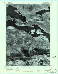
1977 Map of The Horns
USGS Topo · Published 1983About this map
Flagstaff Lake dominates the central landscape of this Somerset County region, its broad waters filling the valley where the Dead River once flowed more narrowly. This 1977 orthophoto provides a photographic record of the terrain as it appeared in the late seventies, showing the intricate shoreline and the surrounding high ground of the Bigelow Range. To the south, the sharp relief of The Horns and West Peak stands in stark contrast to the deep waters below. The image also preserves the location of Myron H. Avery Peak, named for the instrumental Appalachian Trail figure. Further north, the smaller Spring Lake is visible beneath the slopes of Flagstaff Mountain, offering a clear view of the timbered wilderness and water systems that define this part of the Maine woods before more modern developments or shifts in forest management.
Find a feature on this map
7 named features on this map. Tap any name to fly to it.
Don’t see what you’re looking for? This feature index may not catch every label — zoom into the map to look around manually.
Map Details
Editions of this 1977 The Horns Map
This is the sole edition of this map. No revisions or reprints were ever made.
Other maps of this area

1925 · Pierce Pond
USGS Topo · 1:48,000

1927 · Pierce Pond
USGS Topo · 1:62,500

1928 · Spencer
USGS Topo · 1:48,000

1928 · Dead River
USGS Topo · 1:62,500

1928 · Stratton
USGS Topo · 1:48,000

1931 · Dead River
USGS Topo · 1:48,000

1932 · Stratton
USGS Topo · 1:62,500

1932 · Spencer
USGS Topo · 1:62,500

1944 · Dead River
USGS Topo · 1:62,500

1944 · Pierce Pond
USGS Topo · 1:62,500
Featured Places
- Wyman Township, ME
- Flagstaff Township, ME
- Dead River Township, ME
- Spring Lake Township, ME
- Bigelow Township, ME