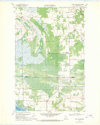
1968 Map of Thief Lake SE
USGS Topo · Published 1971About this map
The Palmville and Moose River townships define this northwestern Minnesota landscape as it appeared in the late 1960s, a region where the transition between drainage and conservation is clearly visible. Large portions of the terrain are designated as the Red Lake Indian Reservation and the Thief Lake State Wildlife Management Area, highlighting the area's importance for resource management. The map documents the intricate water network feeding Thief Lake, including the Moose River and the South Fork Roseau R. Local social and civic life is anchored by several Gravel Pits and public sites like the Townhall and Palmville Cem. These features, along with a network of Jeep Trails and the forested Poplar Grove, reveal a landscape managed for both timber and wildlife at the Roseau and Marshall County line.
Find a feature on this map
16 named features on this map. Tap any name to fly to it.
Don’t see what you’re looking for? This feature index may not catch every label — zoom into the map to look around manually.
Map Details
Editions of this 1968 Thief Lake SE Map
This is the sole edition of this map. No revisions or reprints were ever made.
Other maps of this area

1918 · Rollis
USGS Topo · 1:62,500

1918 · Pencer
USGS Topo · 1:62,500

1918 · Garland
USGS Topo · 1:62,500

1919 · Liner
USGS Topo · 1:62,500

1943 · Rollis
USGS Topo · 1:62,500

1954 · Roseau
USGS Topo · 1:250,000

1957 · Roseau
USGS Topo · 1:250,000

1958 · Roseau
USGS Topo · 1:250,000
1962 · Gatzke NW
USGS Topo · 1:24,000

1962 · Gatzke
USGS Topo · 1:24,000