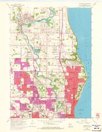
1958 Map of Thiensville
USGS Topo · Published 1973About this map
The Milwaukee River carves a winding path through the northern suburbs of Milwaukee, defining the early development of Thiensville and Mequon. By the mid-1950s, the rural character of the landscape was being rapidly reshaped by residential expansion, marked by the emergence of villages like Bayside and Brown Deer. The map illustrates a significant transitional period where family farms and local institutions, such as the Mequon Cem and St Johns Ch, remained alongside newer developments like the Milwaukee Country Club and Cardinal Stritch College. Significant areas are designated as US Military Reservations near the Lake Michigan shoreline, while the dual paths of the Chicago and North Western and the Chicago Milwaukee St Paul and Pacific railroads provided the vital transportation corridor that tied these lakefront communities to the industrial heart of the city.
Find a feature on this map
70 named features on this map. Tap any name to fly to it.
Don’t see what you’re looking for? This feature index may not catch every label — zoom into the map to look around manually.
Map Details
Editions of this 1958 Thiensville Map
4 editions found
Other maps of this area

1892 · Milwaukee
USGS Topo · 1:62,500

1892 · Waukesha
USGS Topo · 1:62,500

1892 · Port Washington
USGS Topo · 1:62,500

1901 · Milwaukee
USGS Topo · 1:62,500

1901 · Waukesha
USGS Topo · 1:62,500

1904 · West Bend
USGS Topo · 1:62,500

1904 · Port Washington
USGS Topo · 1:62,500

1906 · Waukesha
USGS Topo · 1:62,500

1906 · Milwaukee
USGS Topo · 1:62,500

1954 · Milwaukee
USGS Topo · 1:250,000