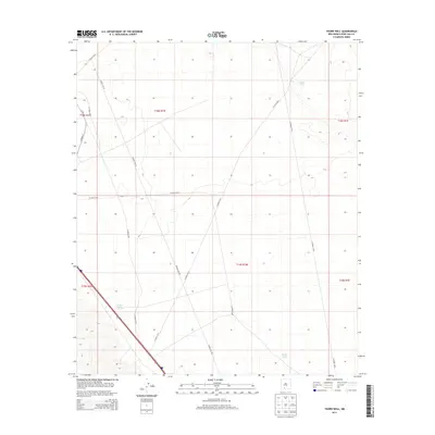
2013 Map of Thorn Well
USGS Topo · Published 2013About this map
Lake Tank and other water management features dot this arid landscape in Doña Ana County during the early 21st century. The map reveals a highly structured grid of section lines and administrative boundaries, including t18s r1w and t19s r1w, which define the ranching and public land divisions of the region. A network of primitive and improved routes provides access to this remote desert area, with Power Line Rd cutting a diagonal path across the landscape, following utility infrastructure. The presence of several catchment basins, such as Caliche Tank and Sump Tank, underscores the critical importance of water storage in this high-desert environment. This survey captures the intersection of traditional land survey systems with modern utility corridors and county roads like Co Road E073.
Find a feature on this map
18 named features on this map. Tap any name to fly to it.
Don’t see what you’re looking for? This feature index may not catch every label — zoom into the map to look around manually.
Map Details
Editions of this 2013 Thorn Well Map
This is the sole edition of this map. No revisions or reprints were ever made.
Other maps of this area

1916 · Tonuco
USGS Topo · 1:125,000

1932 · Tonuco
USGS Topo · 1:125,000

1948 · Chicken Well
USGS Topo · 1:62,500

1948 · San Diego Mountain
USGS Topo · 1:62,500

1955 · Las Cruces
USGS Topo · 1:250,000

1958 · Las Cruces
USGS Topo · 1:250,000
1959 · Sierra Alta
USGS Topo · 1:24,000

1959 · Rincon
USGS Topo · 1:24,000

1959 · Upham
USGS Topo · 1:62,500

1981 · Gilmore Draw
USGS Topo · 1:24,000