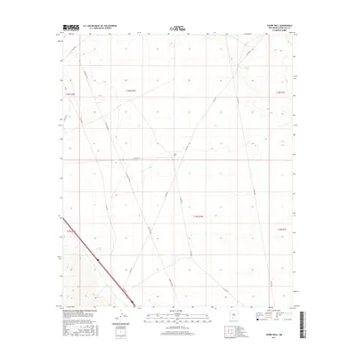
2017 Map of Thorn Well
USGS Topo · Published 2017About this map
Thorn Well and a series of water tanks define the human imprint on this arid landscape in Doña Ana County. Situated within a vast grid of township and range divisions, including t18s r1w and t19s r1w, the area is primarily navigated via a network of county roads and utility corridors. Key infrastructure is represented by the prominent Power Line Rd, which cuts diagonally across the desert floor alongside Co Rd E070 and Co Rd E074. The reliance on managed water sources for ranching or local survival is evident through the placement of Caliche Tank in the northeast and Lake Tank to the southwest. This map illustrates the intersection of public land management and the practical necessities of life in the high desert, where every named well and tank serves as a vital landmark for navigation and livestock.
Find a feature on this map
17 named features on this map. Tap any name to fly to it.
Don’t see what you’re looking for? This feature index may not catch every label — zoom into the map to look around manually.
Map Details
Editions of this 2017 Thorn Well Map
This is the sole edition of this map. No revisions or reprints were ever made.
Other maps of this area

1916 · Tonuco
USGS Topo · 1:125,000

1932 · Tonuco
USGS Topo · 1:125,000

1948 · Chicken Well
USGS Topo · 1:62,500

1948 · San Diego Mountain
USGS Topo · 1:62,500

1955 · Las Cruces
USGS Topo · 1:250,000

1958 · Las Cruces
USGS Topo · 1:250,000
1959 · Sierra Alta
USGS Topo · 1:24,000

1959 · Rincon
USGS Topo · 1:24,000

1959 · Upham
USGS Topo · 1:62,500

1981 · Gilmore Draw
USGS Topo · 1:24,000