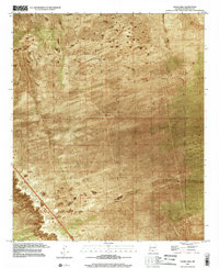
1996 Map of Thorn Well
USGS Topo · Published 2002About this map
Thorn Well serves as the central namesake for this high-desert landscape in Doña Ana County during the mid-1990s. The map reveals a land defined by subsurface water access and cattle ranching infrastructure, where human activity is marked primarily by scattered wells and tanks. The New Mexico Principal Meridian serves as a primary surveying boundary through the region. While the terrain appears largely undeveloped, the presence of South Well, Detroit Tank, and Caliche Tank indicates a carefully managed environment for livestock. Notable industrial remnants include a Drill Hole in the southwestern quadrant, pointing to mineral or water exploration. The map captures this remote section of the Chihuahuan Desert before significant modern shifts, emphasizing the isolation and the vital importance of water catchments like Lake Tank.
Find a feature on this map
7 named features on this map. Tap any name to fly to it.
Don’t see what you’re looking for? This feature index may not catch every label — zoom into the map to look around manually.
Map Details
Editions of this 1996 Thorn Well Map
This is the sole edition of this map. No revisions or reprints were ever made.
Other maps of this area

1916 · Tonuco
USGS Topo · 1:125,000

1932 · Tonuco
USGS Topo · 1:125,000

1948 · Chicken Well
USGS Topo · 1:62,500

1948 · San Diego Mountain
USGS Topo · 1:62,500

1955 · Las Cruces
USGS Topo · 1:250,000

1958 · Las Cruces
USGS Topo · 1:250,000
1959 · Sierra Alta
USGS Topo · 1:24,000

1959 · Rincon
USGS Topo · 1:24,000

1959 · Upham
USGS Topo · 1:62,500

1981 · Gilmore Draw
USGS Topo · 1:24,000