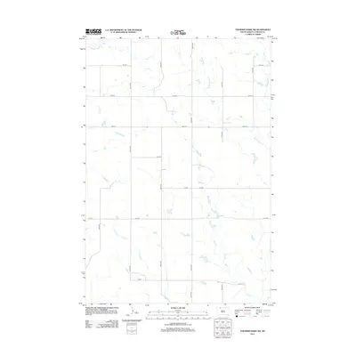
2012 Map of Thunder Hawk SW
USGS Topo · Published 2012About this map
E Thunder Hawk Cr and its tributaries carve a subtle drainage pattern across this high plains landscape of the Rock Creek District. The terrain is organized by a precise grid of rural section roads, including 108th St and 208th Ave, which define the agricultural allotment of Corson County. Small stock ponds and seasonal watercourses like Cyclone Cr and Deer Cr are scattered throughout the quadrangle, reflecting the importance of water management in this semi-arid region. Apart from the intersection of Co Rd and 110th St, the area remains sparsely populated, with the map recording the late twentieth-century development of local roads and water infrastructure that support the ranching economy of northern South Dakota.
Find a feature on this map
20 named features on this map. Tap any name to fly to it.
Don’t see what you’re looking for? This feature index may not catch every label — zoom into the map to look around manually.
Map Details
Editions of this 2012 Thunder Hawk SW Map
This is the sole edition of this map. No revisions or reprints were ever made.
Other maps of this area

1953 · McIntosh
USGS Topo · 1:250,000

1954 · Lemmon
USGS Topo · 1:250,000

1957 · Lemmon
USGS Topo · 1:250,000

1958 · McIntosh
USGS Topo · 1:250,000

1972 · Black Horse Butte NW
USGS Topo · 1:24,000

1972 · Thunder Hawk SW
USGS Topo · 1:24,000

1972 · Thunder Hawk SE
USGS Topo · 1:24,000
1972 · Keldron
USGS Topo · 1:24,000
1972 · Thunder Hawk
USGS Topo · 1:24,000

1972 · Black Horse Butte NE
USGS Topo · 1:24,000