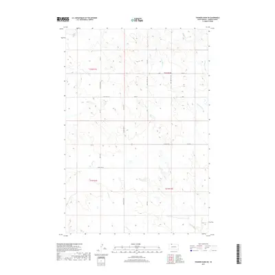
2017 Map of Thunder Hawk SW
USGS Topo · Published 2017About this map
Cyclone Cr and Deer Cr define the drainage patterns of this prairie landscape in Corson County, where the high plains are segmented by a strictly geometric grid of section lines and gravel roads. The terrain is a complex of subtle drainages, including the W Br Willow Cr and the main stem of Willow Cr, which move through an area primarily dedicated to open range and agriculture. The road network reflects the isolation and utility of the region, featuring long thoroughfares like Thunder Hawk Rd and Lemon Lake Rd. More primitive routes such as the 209th Jeep Trail Ave and 110th 4wd Trl suggest a landscape where modern infrastructure meets the rugged requirements of rural land management and local ranching operations during the early 21st century.
Find a feature on this map
22 named features on this map. Tap any name to fly to it.
Don’t see what you’re looking for? This feature index may not catch every label — zoom into the map to look around manually.
Map Details
Editions of this 2017 Thunder Hawk SW Map
This is the sole edition of this map. No revisions or reprints were ever made.
Other maps of this area

1953 · McIntosh
USGS Topo · 1:250,000

1954 · Lemmon
USGS Topo · 1:250,000

1957 · Lemmon
USGS Topo · 1:250,000

1958 · McIntosh
USGS Topo · 1:250,000

1972 · Black Horse Butte NW
USGS Topo · 1:24,000

1972 · Thunder Hawk SW
USGS Topo · 1:24,000

1972 · Thunder Hawk SE
USGS Topo · 1:24,000
1972 · Keldron
USGS Topo · 1:24,000
1972 · Thunder Hawk
USGS Topo · 1:24,000

1972 · Black Horse Butte NE
USGS Topo · 1:24,000